|
- Mt. Bandai is a strato-volcano, with 1819m high, located in the central north of Fukushima prefecture, on the north of Lake Inawashiro. Formed by andesite, it has a trace of crater, called Numano-taira, at its peak. Belonging to Bandai-asahi National Park, the view from the top is splendid. There is Inawashiro Ski Station on its southern skirt.
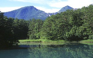
- Bandai Highland, located on the northern skirt of Mt. Bandai at about 800m high is also called Ura-bandai (Back-bandai). It is popular by its numerous lakes and ponds created by an explosion of 1888 like Hibara, Onogawa, Akimoto and Goshiki, and the beauty of its forest.
- Mt Bandai exploded suddenly on July 1888: It blew off Sho-bandai located at the northern crater wall and formed a hoofed one. Volcano fragments fell over the villages on its northern skirt and provoked a huge damage: 461 persons were killed. Moreover a mud stream blocked valleys to create many lakes and ponds.
- More than 200 lakes and ponds dispersed in Bandai Highland are called Gosiki-numa (5 Color Ponds). The principal ponds are Rushamon, Benten, Ruri, Ao etc. The water has filled up the depressed grounds, originated from a mud stream provoked by the Bandai's explosion of 1888 and depending on the kinds of ions or deposits and the depth of ponds, they have taken different colors such as green, blue and red.
|

 Japanese display
 French display

